


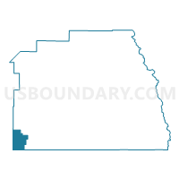
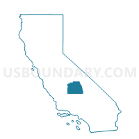
Voting District 21800, Tulare County, California
About
Outline

Summary
| Unique Area Identifier | 545307 |
| Name | Voting District 21800 |
| County | Tulare County |
| State | California |
| Area (square miles) | 70.12 |
| Land Area (square miles) | 70.12 |
| Water Area (square miles) | 0.00 |
| % of Land Area | 100.00 |
| % of Water Area | 0.00 |
| Latitude of the Internal Point | 35.86576130 |
| Longtitude of the Internal Point | -119.47841860 |
Maps

Graphs
Select a template below for downloading or customizing gragh for Voting District 21800, Tulare County, California


Neighbors
Neighoring Voting District (by Name) Neighboring Voting District on the Map
- Voting District 20405, Kings County, CA
- Voting District 20445, Kings County, CA
- Voting District 20470, Kings County, CA
- Voting District 21455, Tulare County, CA
- Voting District 21475, Tulare County, CA
- Voting District 21585, Tulare County, CA
- Voting District 21715, Tulare County, CA
- Voting District 22060, Tulare County, CA
- Voting District 40005, Kern County, CA
Top 10 Neighboring County Subdivision (by Population) Neighboring County Subdivision on the Map
- Wasco CCD, Kern County, CA (29,808)
- Stratford CCD, Kings County, CA (16,634)
- Earlimart CCD, Tulare County, CA (15,152)
- Pixley CCD, Tulare County, CA (6,529)
Top 10 Neighboring Place (by Population) Neighboring Place on the Map
Top 10 Neighboring Elementary School District (by Population) Neighboring Elementary School District on the Map
- Earlimart Elementary School District, CA (10,604)
- Pixley Union Elementary School District, CA (5,199)
- Pond Union Elementary School District, CA (692)
- Allensworth Elementary School District, CA (476)
Top 10 Neighboring Secondary School District (by Population) Neighboring Secondary School District on the Map
- Tulare Joint Union High School District, CA (78,539)
- Delano Joint Union High School District, CA (70,221)
Top 10 Neighboring Unified School District (by Population) Neighboring Unified School District on the Map
Top 10 Neighboring State Legislative District Lower Chamber (by Population) Neighboring State Legislative District Lower Chamber on the Map
Top 10 Neighboring State Legislative District Upper Chamber (by Population) Neighboring State Legislative District Upper Chamber on the Map
Top 10 Neighboring 111th Congressional District (by Population) Neighboring 111th Congressional District on the Map
Top 10 Neighboring Census Tract (by Population) Neighboring Census Tract on the Map
- Census Tract 43, Tulare County, CA (7,682)
- Census Tract 42, Tulare County, CA (6,529)
- Census Tract 16.01, Kings County, CA (4,516)
- Census Tract 45, Kern County, CA (3,937)
Top 10 Neighboring 5-Digit ZIP Code Tabulation Area (by Population) Neighboring 5-Digit ZIP Code Tabulation Area on the Map
- 93280, CA (27,152)
- 93212, CA (26,079)
- 93219, CA (10,194)
- 93256, CA (5,753)
- 93239, CA (1,688)
- 93201, CA (1,348)